
Wayshowing System for Decorah Trails
Project Overview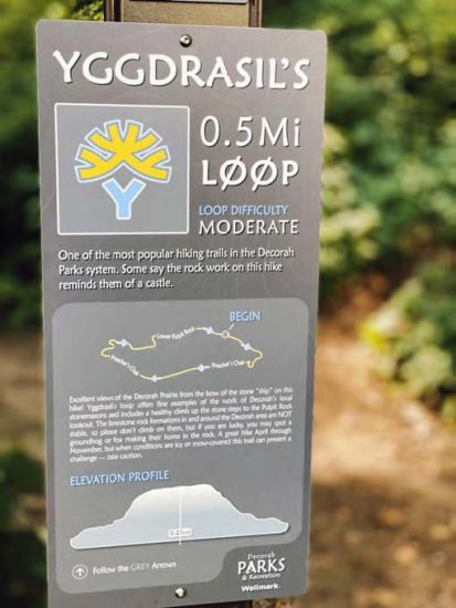
The Decorah Parks and Recreation Department manages a 20-mile network of soft trails popular with mountain bikers, hikers, and horseback riders. Unfortunately, as this trail system expanded in miles and increased in use over the years, corresponding trail signage, informational kiosks, promotional material, and safety infrastructure improvements did not keep pace.
Northeast Iowa RC&D led a team of stakeholders and community members in planning, developing, designing, and installing an extensive trail branding, mapping, and wayshowing system with the goals of improving trail usability and safety and enhancing community wellness.
The trails’ diverse environments, terrains, and users required that wayshowing materials provide a wide range of detailed information, including trail identification markers, route maps, directional arrows, difficulty ratings, safety considerations, and points of interest. User safety was a priority, so trail signs were also assigned unique IDs on the US National Grid, enabling users to precisely communicate their location to emergency responders.
Creating a series of loop routes of further enhanced accessibility for new, visiting, or novice trail users who can easily be intimidated or confused by the maze of trails that make up the trail network. The team created and installed ten unique and easy-to-follow looped routes that varied in distance, terrain, difficulty, and features of interest; the loop names highlight symbols and stories from Norse mythology, connecting to the rich, local Norwegian heritage of the Decorah community.
The project ultimately resulted in the creation and installation of more than 150 trail markers, 10 loop trailhead markers, and 8 large informational kiosks, as well as the design and production of 7,500 printed pocket maps. RC&D’s extensive project management expertise was essential in every stage of the process, from facilitating stakeholder and public input, to route and loop mapping, to design, fabrication, and installation of markers, kiosks, and maps.
Printed maps are available at the Decorah Visitors Center (507 West Water Street) or Decorah Parks and Recreation office (400 Claiborne Drive).
Project Funders and Partners

Project Photos
[ngg src=”galleries” ids=”18″ display=”basic_thumbnail”]